

GIS Industry Trends and Applications: How Geospatial Technology Is Transforming Businesses in 2026
Understanding GIS and Its Growing Importance
What Is Geographic Information Systems (GIS)?
Geographic Information Systems, commonly known as GIS, represent a powerful combination of hardware, software, data, and analytical methods used to capture, manage, analyze, and visualize location-based information. While maps remain one of the most recognizable outputs of GIS, modern geospatial technology goes far beyond traditional cartography. Today, GIS serves as a sophisticated decision-support system capable of uncovering patterns, predicting outcomes, and helping organizations make informed choices based on spatial relationships.
Think of GIS as the digital nervous system of a location-aware world. Every smartphone navigation route, disaster response plan, urban development project, and agricultural monitoring program increasingly relies on geospatial intelligence. Organizations are collecting enormous volumes of location data from satellites, drones, sensors, mobile devices, and connected infrastructure. GIS transforms this raw information into actionable insights that decision-makers can understand and apply.
Meanwhile, the rise of digital transformation initiatives across industries has elevated GIS from a specialized technical tool into a strategic business asset. Governments use it to improve public services, businesses leverage it to optimize operations, and researchers depend on it to understand complex environmental and social challenges. The growing accessibility of cloud computing, AI-powered analytics, and web-based mapping platforms has also expanded GIS adoption among organizations of all sizes.
Why GIS Matters More Than Ever
The modern economy is increasingly location-driven. Whether a company is delivering products, managing infrastructure, planning investments, or responding to emergencies, location intelligence plays a critical role. GIS provides the framework needed to understand where events occur, why they happen, and how organizations can respond effectively.
Today, businesses face unprecedented complexity. Supply chains stretch across continents, urban populations continue to expand, and climate-related risks create new challenges for governments and corporations alike. GIS helps organizations visualize these complexities and identify solutions that might otherwise remain hidden within massive datasets.
The importance of GIS has become even more apparent with the growth of smart cities, autonomous systems, environmental monitoring programs, and digital infrastructure initiatives. Real-time spatial awareness allows decision-makers to react faster and allocate resources more effectively. As a result, GIS is increasingly becoming a core technology layer embedded within enterprise systems rather than a standalone mapping application. Recent industry analysis also highlights the convergence of GIS with AI, IoT, satellite imagery, and advanced analytics, creating entirely new possibilities for geospatial intelligence.
The Current State of the GIS Industry
Market Growth and Industry Statistics
The GIS and geospatial analytics industry is experiencing remarkable growth. According to recent market research, the global geospatial analytics market was valued at approximately USD 102.67 billion in 2025 and is projected to reach USD 234.01 billion by 2033, representing a compound annual growth rate of 10.4%.
| GIS Industry Metric | Value |
|---|---|
| Global Market Size (2025) | USD 102.67 Billion |
| Projected Market Size (2033) | USD 234.01 Billion |
| CAGR (2026-2033) | 10.4% |
| Largest Regional Market | North America |
| Fastest Growing Region | Asia Pacific |
Several factors contribute to this expansion. Organizations increasingly recognize the value of spatial analytics for operational efficiency, customer engagement, sustainability initiatives, and risk management. At the same time, technological advancements continue to lower barriers to adoption, making GIS solutions more accessible than ever before.
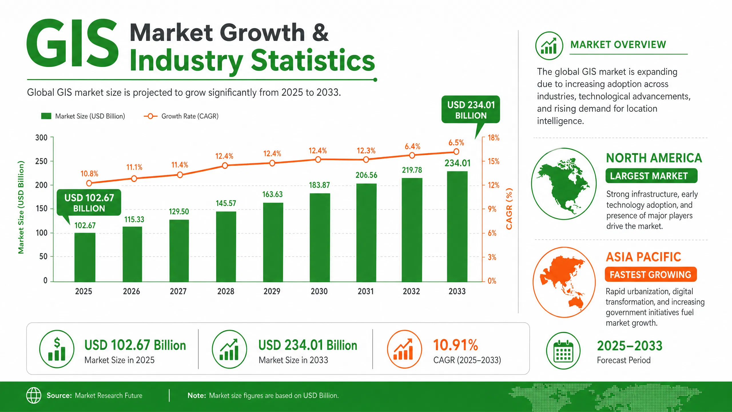
Additionally, government investments in infrastructure modernization, environmental monitoring, defense applications, and smart city initiatives are generating significant demand for geospatial technologies worldwide. Industries ranging from agriculture to telecommunications now rely heavily on location intelligence to remain competitive in rapidly evolving markets.
Key Drivers of GIS Adoption
The growth of GIS is not happening in isolation. Multiple technological and economic trends are reinforcing each other to accelerate adoption. One major driver is the explosion of location-based data generated by smartphones, connected devices, drones, and satellites. Organizations need sophisticated tools to process and analyze these data streams effectively.
At the same time, cloud computing has transformed GIS deployment models. Businesses no longer need expensive on-premises infrastructure to access advanced geospatial capabilities. Cloud platforms provide scalability, flexibility, and real-time collaboration opportunities that support distributed workforces and global operations.
The increasing emphasis on sustainability, climate resilience, and resource optimization also contributes to GIS growth. Companies and governments require accurate spatial information to track environmental changes, assess risks, and develop evidence-based strategies. As data volumes continue to expand, GIS serves as the critical bridge between raw information and practical decision-making.
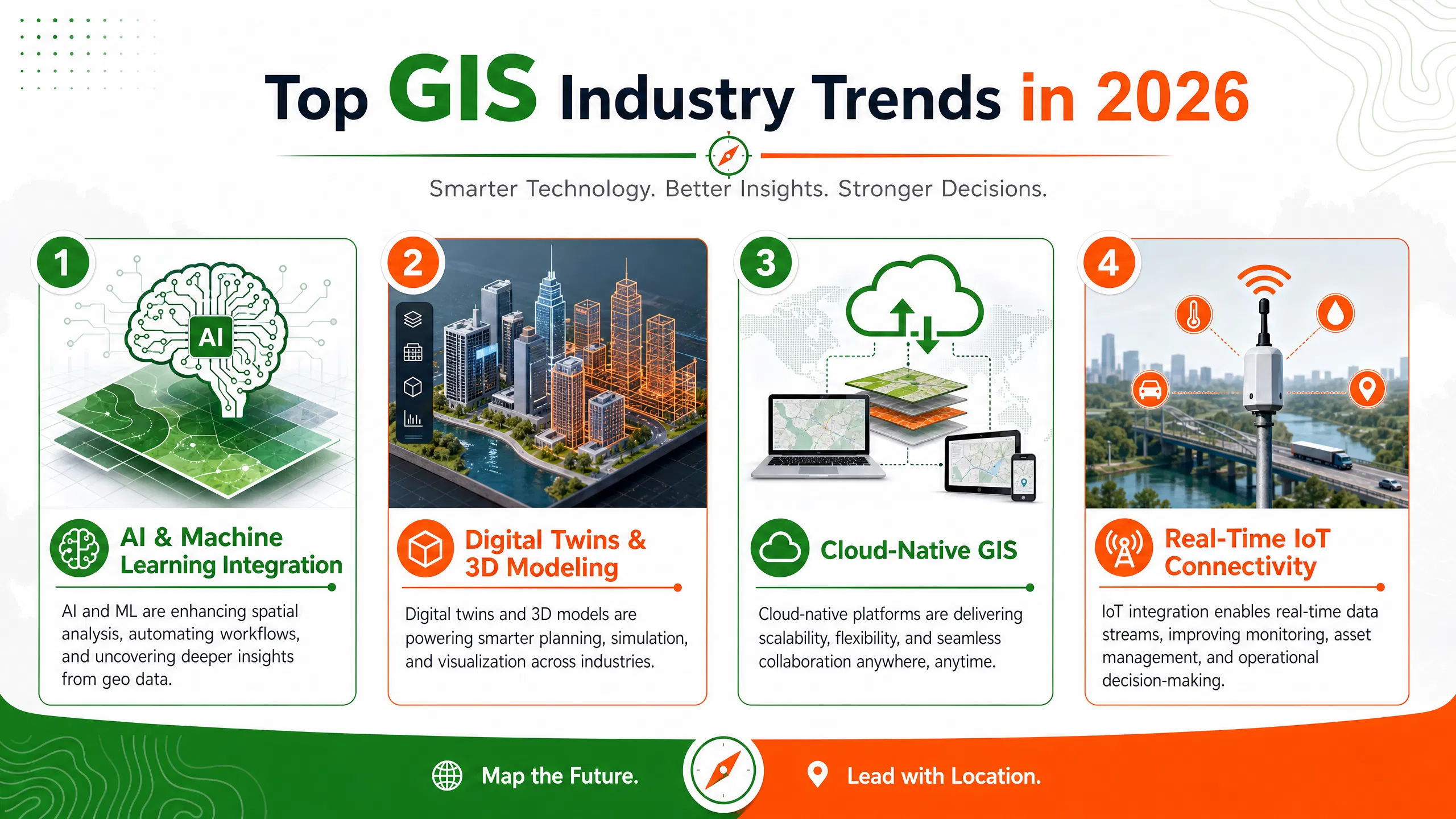
Top GIS Industry Trends in 2026
Artificial Intelligence and GIS Integration
Artificial Intelligence is arguably the most influential force shaping the future of GIS. Modern GIS platforms increasingly incorporate machine learning algorithms, computer vision, natural language processing, and predictive analytics capabilities. These technologies automate complex workflows and uncover insights that would be difficult or impossible to identify manually.
Recent developments demonstrate how AI is transforming geospatial analysis. Leading GIS vendors are integrating AI assistants directly into mapping platforms, enabling users to interact with spatial data using natural language queries. AI-powered object detection systems can automatically identify infrastructure, environmental features, and assets from satellite imagery and drone surveys.
Researchers are even exploring the concept of Autonomous GIS, where AI systems independently retrieve geospatial data, perform analyses, and generate maps with minimal human intervention. This emerging field could fundamentally reshape how organizations use geospatial technologies in the coming decade.
Digital Twins and 3D Geospatial Modeling
Digital twins have evolved from industry buzzwords into practical tools for urban planning, infrastructure management, and operational optimization. A digital twin combines real-world data with virtual representations of physical environments, enabling organizations to simulate scenarios and evaluate outcomes before implementing changes.
Modern GIS platforms now support highly detailed 3D visualization, immersive modeling environments, and real-time data integration. These capabilities allow planners, engineers, and decision-makers to better understand complex systems and identify potential challenges before they occur.
Consequently, cities can evaluate transportation projects, utilities can monitor infrastructure performance, and facility managers can optimize operations using spatially enabled digital replicas. Advances in AI-generated 3D modeling and geospatial visualization technologies are further accelerating digital twin adoption across multiple industries.
Cloud-Based GIS Platforms
Cloud-native GIS solutions continue to gain momentum because they offer scalability, cost efficiency, and accessibility. Organizations can store massive geospatial datasets, perform advanced analytics, and share results globally without maintaining extensive physical infrastructure.
Cloud GIS supports collaborative workflows where teams across different locations can access the same datasets and applications in real time. This capability has become particularly important as organizations embrace hybrid and remote working models.
Equally important, cloud environments facilitate integration with emerging technologies such as AI, IoT, and big data analytics. These interconnected ecosystems enable organizations to create comprehensive digital workflows that support data-driven decision-making across departments and geographic regions.
Real-Time GIS and IoT Connectivity
The Internet of Things is transforming GIS from a historical analysis tool into a real-time operational platform. Sensors embedded in vehicles, buildings, utilities, and infrastructure continuously generate data streams that can be visualized and analyzed within GIS environments.
Real-time GIS applications support traffic management, fleet optimization, environmental monitoring, utility operations, and emergency response. Decision-makers gain immediate visibility into changing conditions, allowing them to respond quickly and effectively.
Industry experts increasingly describe GIS as an intelligence platform that connects diverse data systems rather than simply displaying maps. The convergence of IoT, AI, and geospatial technologies is creating powerful new opportunities for operational awareness and predictive decision-making.
Drone Mapping and Remote Sensing
Drone technology continues to revolutionize geospatial data collection. Organizations can now capture high-resolution imagery, topographic information, and environmental measurements faster and more cost-effectively than traditional surveying methods.
Industries such as agriculture, mining, construction, utilities, and environmental management increasingly depend on drone-based GIS workflows. These technologies improve safety, reduce operational costs, and provide access to locations that may be difficult or dangerous for field personnel.
Simultaneously, advances in satellite imaging and remote sensing technologies are expanding the availability of near-real-time geospatial information. Organizations can monitor land use changes, environmental conditions, infrastructure development, and disaster impacts with unprecedented accuracy and frequency.
Open Geospatial Data and Interoperability
Open data initiatives are making geospatial information more accessible than ever before. Governments, research institutions, and international organizations increasingly share datasets that support innovation and collaboration.
Interoperability standards ensure that different GIS platforms, databases, and analytical tools can work together effectively. This trend reduces data silos and enables organizations to integrate spatial information across diverse systems.
As a result, businesses gain access to richer datasets while reducing duplication of effort. Open ecosystems encourage experimentation, foster innovation, and help organizations maximize the value of geospatial investments.
Major GIS Applications Across Industries
Urban Planning and Smart Cities
Smart city initiatives rely heavily on GIS for planning, monitoring, and optimization. City planners use geospatial analysis to evaluate land use patterns, transportation networks, utility infrastructure, and population growth trends. GIS enables evidence-based decision-making that improves urban livability and sustainability.
Agriculture and Precision Farming
Precision agriculture represents one of the fastest-growing GIS applications. Farmers use geospatial technologies to monitor crop health, assess soil conditions, optimize irrigation systems, and improve yield forecasts. Drone imagery, satellite data, and sensor networks provide detailed insights that support data-driven agricultural management.
Environmental Monitoring and Climate Resilience
Environmental agencies and private organizations increasingly rely on GIS to track climate risks, monitor ecosystems, and evaluate sustainability initiatives. Spatial analytics support flood modeling, wildfire risk assessment, biodiversity conservation, and carbon management programs. The growing demand for climate intelligence is creating new opportunities for geospatial innovation.
Transportation and Logistics
Location intelligence has become indispensable for logistics operations. GIS supports route optimization, fleet management, warehouse planning, and supply chain visibility. Companies can reduce costs, improve delivery performance, and enhance customer satisfaction through spatially informed decision-making.
Utilities and Infrastructure Management
Utility providers use GIS to manage assets, monitor networks, plan maintenance activities, and respond to service disruptions. Digital infrastructure maps improve operational efficiency while supporting long-term investment planning.
Public Health and Disaster Management
GIS plays a critical role in emergency preparedness and response. Organizations use spatial analysis to identify vulnerable populations, allocate resources, monitor disease outbreaks, and coordinate disaster relief operations. These capabilities help save lives and improve resilience during crises.
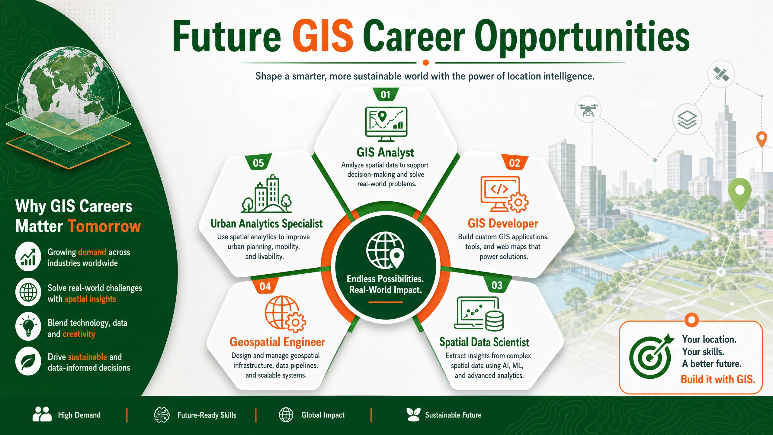
Skills and Training Needed for the Future GIS Workforce
Emerging GIS Career Opportunities
The GIS workforce is evolving rapidly. Traditional mapping skills remain valuable, but employers increasingly seek professionals who combine geospatial expertise with data science, programming, cloud computing, and AI capabilities. Research indicates that GIS continues to represent a significant growth area within the broader technology sector.
Popular career paths include:
- GIS Analyst
- GIS Developer
- Remote Sensing Specialist
- Spatial Data Scientist
- Geospatial Engineer
- Urban Analytics Specialist
- Environmental GIS Consultant
Recommended GIS Training Paths
Professionals seeking to remain competitive should continuously update their skills. High-quality training programs can help learners master both foundational concepts and emerging technologies.
Recommended learning resources include:
- GIS and Remote Sensing Training Courses
- ArcGIS Training Programs
- QGIS Professional Training
- Spatial Data Analysis Courses
- Drone Mapping and GIS Training
- Digital Transformation and Technology Solutions
Challenges Facing the GIS Industry
Data Quality and Privacy Concerns
As organizations collect increasing volumes of geospatial information, ensuring data quality becomes more challenging. Inaccurate or outdated data can lead to poor decisions, operational inefficiencies, and financial losses. Maintaining reliable datasets requires strong governance frameworks and ongoing validation processes.
Privacy concerns also continue to grow. Location data can reveal sensitive information about individuals, businesses, and critical infrastructure. Organizations must balance innovation with ethical data management practices and regulatory compliance requirements.
Skills Gaps and Technology Adoption
Although GIS adoption is accelerating, many organizations struggle to find professionals with the required technical expertise. The integration of AI, cloud computing, and advanced analytics has expanded skill requirements beyond traditional GIS competencies.
Organizations must invest in workforce development initiatives and continuous learning programs to address these challenges effectively. Building multidisciplinary teams that combine geospatial knowledge with data science and software engineering expertise will become increasingly important.
The Future of GIS Beyond 2030
The future of GIS appears exceptionally promising. Geospatial intelligence is steadily transitioning from a specialized discipline into a foundational component of digital ecosystems. AI-powered automation, real-time analytics, digital twins, autonomous systems, and pervasive sensing technologies will continue to expand the role of GIS across industries.
Experts increasingly envision a future where GIS functions as an invisible intelligence layer embedded within decision-making processes. Rather than producing static maps, geospatial systems will continuously analyze conditions, generate recommendations, and support autonomous operations. The convergence of AI, satellite imagery, IoT networks, and advanced analytics is laying the groundwork for this transformation today.
Conclusion
The GIS industry is experiencing one of the most significant periods of transformation in its history. Driven by artificial intelligence, cloud computing, digital twins, IoT connectivity, drone technologies, and expanding data availability, GIS has evolved far beyond traditional mapping applications. Organizations across virtually every sector now rely on geospatial intelligence to improve efficiency, reduce risk, enhance sustainability, and make smarter decisions.
With the global geospatial analytics market projected to more than double by 2033, the opportunities for businesses and professionals continue to expand. Those who embrace emerging technologies, invest in modern GIS skills, and integrate location intelligence into strategic planning will be best positioned to thrive in the increasingly data-driven future.
Frequently Asked Questions
1. What is the biggest trend in the GIS industry today?
The integration of Artificial Intelligence with GIS is currently the most influential trend, enabling automated analysis, predictive modeling, object detection, and intelligent decision support.
2. Which industries use GIS the most?
Major GIS users include urban planning, agriculture, transportation, logistics, utilities, environmental management, public health, defense, and disaster response sectors.
3. Is GIS a good career in 2026?
Yes. GIS remains a growing field with opportunities in spatial analytics, remote sensing, geospatial software development, environmental consulting, and smart city initiatives.
4. How is AI changing GIS?
AI automates geospatial workflows, improves predictive analytics, enhances image classification, supports natural language interactions, and enables advanced decision-making capabilities.
5. What skills are needed for future GIS professionals?
Future GIS professionals should develop expertise in GIS software, spatial analysis, Python programming, cloud computing, remote sensing, data science, machine learning, and database management.

