

GeoAI and Machine Learning for Earth Observation involve the integration of artificial intelligence with geospatial data to automate the analysis of satellite and aerial imagery for real-world decision-making. In Africa, this synergy is essential for addressing critical challenges in precision agriculture, urban resilience, and natural resource management by turning massive datasets into actionable intelligence.
What is GeoAI and Machine Learning for Earth Observation?
GeoAI (Geospatial Artificial Intelligence) is the application of AI techniques specifically machine learning (ML) and deep learning to geographic data. When applied to Earth Observation (EO), it allows systems to “see” and interpret the planet’s surface at a scale impossible for human analysts.
In 2026, high-resolution imagery (down to 30cm) is the industry standard. However, the sheer volume of this data requires ML models to automate feature extraction, such as identifying crop stress, detecting illegal construction, or monitoring infrastructure health in real-time. For organizations in Nairobi, Kenya, and across the continent, mastering these tools is the key to localizing global technological shifts.
Why Does GeoAI Training Matter for African Organizations?
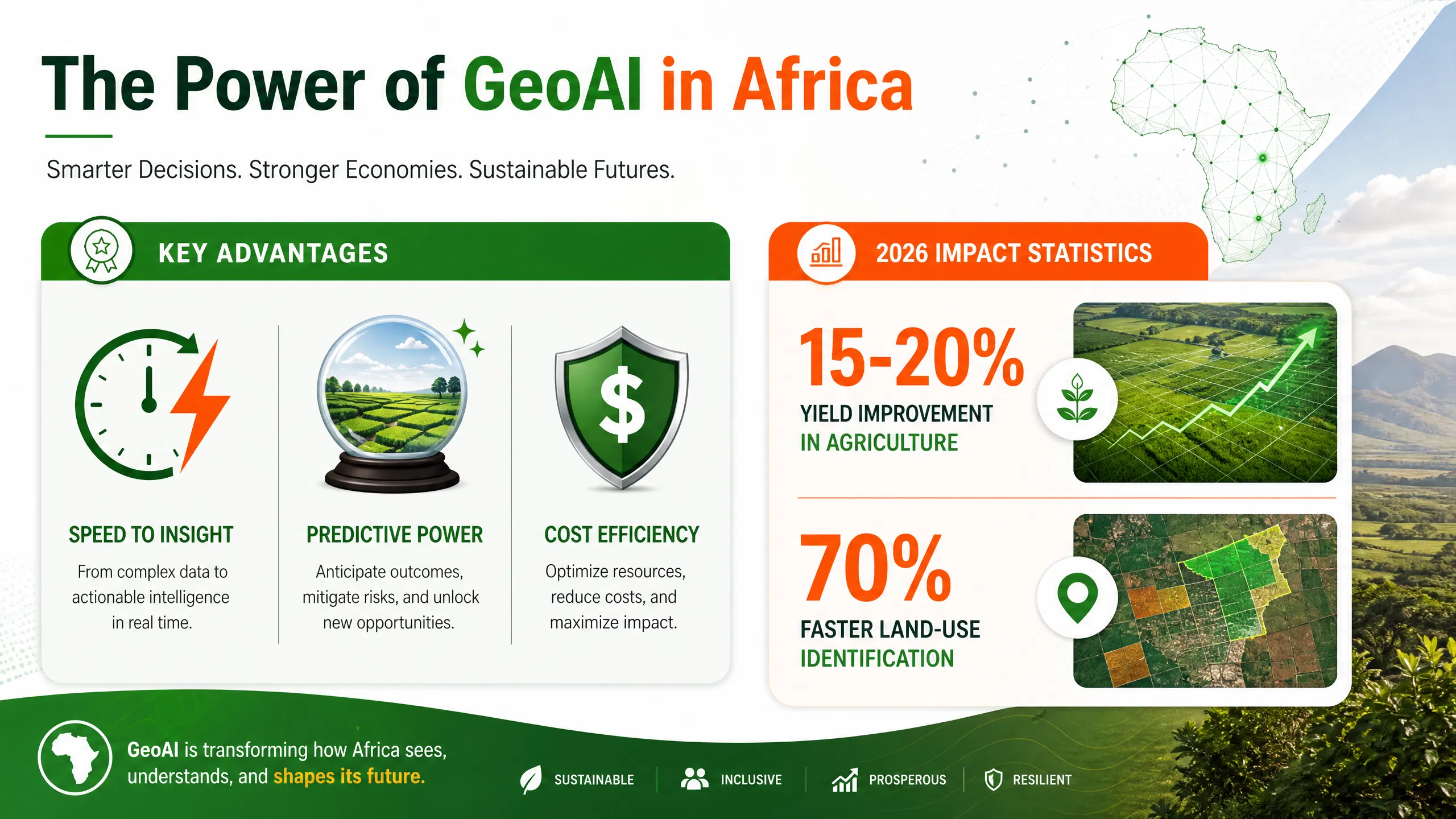
The African landscape is changing rapidly. From the expansion of cities like Lagos and Nairobi to the fluctuating yields in the Rift Valley, traditional mapping is too slow. Professional development in GeoAI offers three primary advantages:
-
Speed to Insight: Traditional GIS analysis can take weeks; ML models can process an entire country’s land cover in hours.
-
Predictive Power: Beyond seeing what is there, ML helps predict what will happen—such as forecasting drought impacts or urban flood risks.
-
Cost Efficiency: Automating manual data workflows reduces operational costs and allows human experts to focus on strategy rather than digitizing maps.
At ForElite Training Institute, our specialized courses empower teams to harness these technologies using NITA-compliant frameworks.
Practical Steps to Implementing GeoAI in Your Workflow
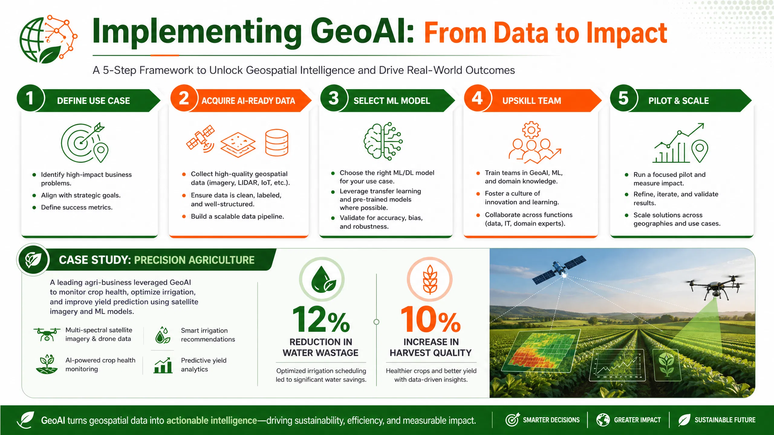
Transitioning to an AI-augmented EO framework requires a structured approach:
-
Define the Business Use Case: Identify a specific problem, such as “reducing non-revenue water” or “monitoring forest degradation.”
-
Acquire AI-Ready Data: Use open-access sources like Sentinel-2 or commercial high-res providers, ensuring the data is pre-processed for ML.
-
Select the Right Model: Choose between supervised learning (using labeled data) or unsupervised learning depending on your goal.
-
Upskill Your Team: Partner with an experienced training provider to move your GIS department from manual analysis to automated pipelines.
-
Pilot and Scale: Start with a small geographic area to validate model accuracy before a national-scale rollout.
Supporting Data and Case Studies
Key Statistics in 2026
-
Economic Impact: Leveraging GeoAI in agriculture alone could improve yields by 15-20% across Sub-Saharan Africa by enabling precision interventions (Satpalda, 2026).
-
Labor Efficiency: AI-powered EO platforms can identify land-use changes 70% faster than traditional manual survey methods (UN-Habitat, 2025).
-
Investment Growth: The global Earth Observation market is increasingly driven by AI, with the “solutions-as-a-service” sector growing at a CAGR of over 12% as businesses move from raw data to actionable insights.
Case Study: Urban Resilience in Kenya
The UN-Habitat GeoAI Toolkit has been used to support urban planners in African cities to understand land-use dynamics. By applying ML to satellite data, planners in regions similar to Nairobi have successfully mapped informal settlements and accessed basic services, allowing for better allocation of limited municipal resources (UN-Habitat, 2025).
Business Outcome Example: Precision Agriculture
A large-scale tea plantation in East Africa implemented a GeoAI monitoring system to track soil moisture and leaf health.
-
The Result: A 12% reduction in water wastage and a 10% increase in harvest quality.
-
Why it matters: This shows that GeoAI isn’t just for researchers; it is a vital tool for the corporate sector to ensure sustainability and profit.
FAQ: GeoAI and Machine Learning for Earth Observation
What is the difference between GIS and GeoAI?
Traditional GIS (Geographic Information Systems) focuses on storing and analyzing spatial data manually. GeoAI uses Machine Learning to automate that analysis and make predictions based on patterns in the data.
Do I need to be a coder to use GeoAI?
While coding (Python/R) is helpful for custom models, many modern EO platforms now offer “no-code” or “low-code” AI tools. However, professional training is recommended to understand the underlying logic and data ethics.
How does Earth Observation help with climate change in Africa?
EO provides “climate intelligence” by monitoring deforestation, sea-level rise, and carbon stocks. AI helps process this data to provide ESG reporting and early warning systems for natural disasters.
Is GeoAI training NITA-approved in Kenya?
Yes, training programs from registered institutes like ForElite Training Institute are eligible for NITA reimbursements, making it cost-effective for Kenyan companies to upskill their staff.
Conclusion
Mastering GeoAI and Machine Learning for Earth Observation is the most effective way for African organizations to bridge the gap between big data and big impact. By automating the interpretation of our changing planet, businesses and governments can make faster, smarter, and more sustainable decisions.
Whether you are in urban planning, agriculture, or environmental conservation, the future of your industry is spatial. Contact ForElite Training Institute today to explore our upcoming training calendar and take the first step toward becoming a leader in the African geospatial revolution.
References
-
Satpalda. (2026). The State of Earth Observation in 2026: Technologies, Trends, and Use Cases.
-
UN-Habitat. (2025). AI for Spatial Mapping and Analysis – GeoAI Toolkit for Urban Planners.
-
ResearchGate. (2025). Integration of Earth Observation and AI for Earth’s resource management and governance.

